
By Lia Slemons
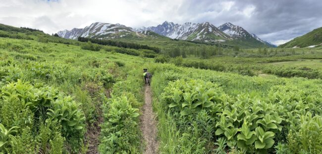 Johnson Pass Trail allows backcountry access through spruce forests to striking subalpine lakes. Today winter visitors share the trail with recreating skiers, winter bikers, equestrians, and snowmachiners (snow depth dependent). Travelers are expected to leave the popular trail unaltered. This was far from the case in 1904 when Congress summoned all men age 18 or older residing in Alaska to build roads two days a year or pay an annual $8 tax.
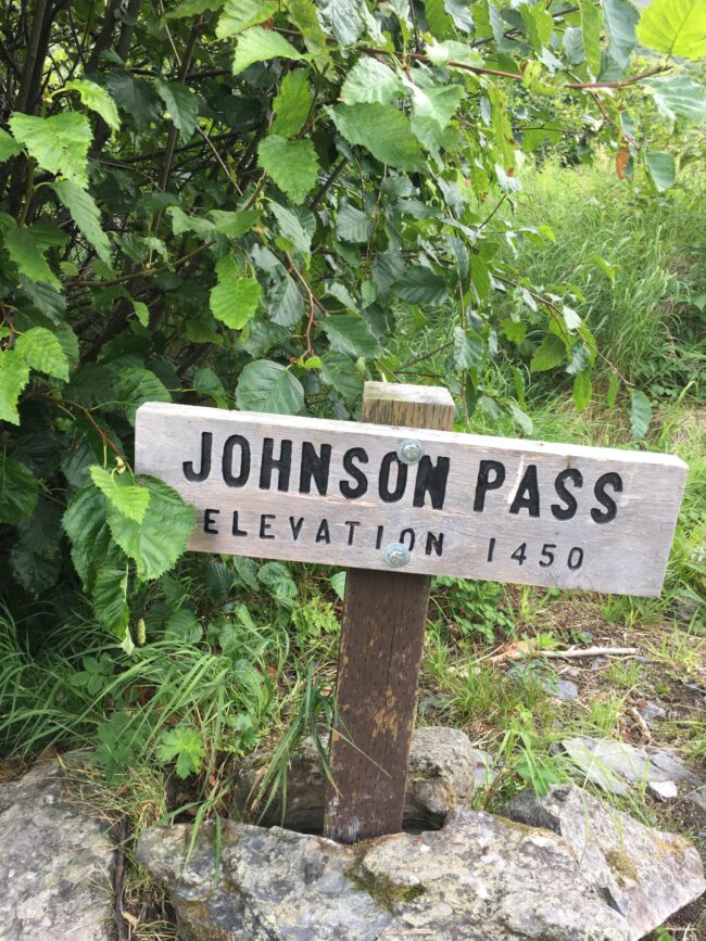
The recreational Johnson Pass Trail managed by Chugach National Forest today repeatedly overlaps the historic Johnson Pass Military Road built in the early days of United States infrastructure investments. If you know what to look for, cuts and fills north of Bench Lake provide clues, as does the older “corduroy” of logs laid across boggy sections of the roadbed mixed in with newer logs and aluminum culverts. If you don’t know what to look for, Chugach National Forest commissioned a survey of the historic road in 1991 with detailed maps. Winter was the original high season for Johnson Pass travel, when rivers froze for smoother travel and Cook Inlet shipping was interrupted by ice.
Predictably, the chaotic approach of a citizens’ labor summons did not open up roads through Alaska, but the 1904 law did signal a federal push to develop infrastructure in the seemingly open and yet intractably impassable Territory of Alaska. The Secretary of War oversaw federal funding and construction of roads, including the Johnson Pass Military Road in 1907, also known as Sunrise Road. This early road ran from Mile 34 of the Alaska Railroad through Johnson Pass, across Lynx Creek and down the west side of Sixmile Creek to Sunrise. The recreational Johnson Pass Trail managed by Chugach National Forest today follows much of the same southern route, and the Seward and Hope Highways follow much of the same northern route.
Travel in Alaska has long been a function of the season. Dena’ina people traveled extensively in winter, often for distant potlaches, by snowshoe, using frozen waterways. Most trails in Turnagain and Kenai originated from Dena’ina routes.
Gold prospecting drove the demand for year-round shipping routes. The Turnagain Arm gold rush kicked off with 3,000 gold seekers in 1896. For the next few decades, dog teams were the most reliable way to haul freight during the winter until supplanted by aviation in the 1920s. The Alaska Road Commission, under the Secretary of War, surveyed and constructed routes to Alaska’s gold fields. This network of trails became known as the Iditarod Trail.
Roadhouses along the Iditarod trail network sheltered mail carriers linking communities by dog team through snow, storm, and avalanches. At least three roadhouses operated along the Johnson Pass Military Road. In addition, prospectors built cabins near promising claims. The remains of a cabin noted on a 1910 map north of the Groundhog Creek bridge are indistinct, but evidence of another cabin and barn have been recorded at a site off-trail along the old road.
The Road Commission built three classes of road: wagon, winter sled, and pack and dog team trails. Wagon roads accommodated horse teams, which meant grading, crowning, and ditching the route. Johnson Pass Military Road was a wagon road, launching it as a key corridor to gold regions. The estimated cost of construction in 1907 was $13,000, including the hire of 25 men and a 40-foot-high, 60-foot-long bridge across Groundhog Creek. Big stumps were left in place to manage costs. Between June and October of 1907, the Johnson Pass route was converted to a 12-foot-wide wagon road. The 1909 Alaska Road Commission report recorded approximately 150 tons of freight hauled the previous winter.
As prospecting shifted, so did the fate of the road. By 1909, a trail leading northwest from Moose Pass to Quartz Creek was upgraded and travel shifted to this gentler, more sheltered route. At the same time, gold production in Sunrise and Hope were waning. A one-season boom in 1910 on Groundhog Creek revived use for a short period. Johnson Pass Military Road was maintained until 1920, when the southern section was abandoned. That abandonment contributed to its relative preservation, because it did not become a modern highway.
 Today’s 23-mile Johnson Pass Trail is a modern trail, with Forest Service outhouses, bears boxes, and designated campsites. Snowmachiners need to verify if there’s enough snow cover before venturing into Chugach National Forest. The Avalanche Information site posts openings and closures at http://www.cnfaic.org/advisories/current.php.
The North and South trailheads are at mile 63.7 and 32.6 of the Seward Highway, although parking lots may not be plowed. From the north, winter non-motorized users should take the Johnson Pass Wagon Road at the western edge of the North trailhead parking lot rather than the hiking trail. The first 3.6 miles of trail, to the south side of Bench Creek Bridge, are closed to motorized users. Snowmachiners can travel up a mining road leading west from the North trailhead, cross East Fork Sixmile Creek, and head south to intersect the trail south of Bench Creek Bridge. From the south, when Upper Trail Lake is frozen, use it to connect to the Johnson Pass Trail at mile 7.9 via the Johnson Creek winter route.
The same perils encountered by earlier travelers exist today. Snowstorms can quickly obscure the route above tree line in the winter. There is a report of an uncomfortably curious wolf following a solo biker. Some sections of the trail pass between steep, avalanche-prone slopes and creeks. Snowpack and recent and forecast weather must be evaluated before you go. The Chugach National Forest Avalanche Information Center provides general conditions assessments, local weather, education resources links, and user-reported updates. This starting-point website is located at http://www.cnfaic.org.
If you explore Johnson Pass Trail this winter, you are passing through history as well as hemlock. Kenai Mountains Turnagain Arm National Heritage Area promotes and protects the heritage and continued use of corridors connecting Alaskan communities.
 Lia Slemons is a former Trails Coordinator for KMTA. She endeavors to learn the region’s trails both as an avid trail runner, recreational skier, nascent mountain biker, and expert candy-carrying mother and through their history, ancient and recent.